Wanstead has changed considerably over the past 160 years. Ahead of a talk at Wanstead Library this month, Dr Colin Runeckles discusses his work cataloguing local building plans dating back to 1858.
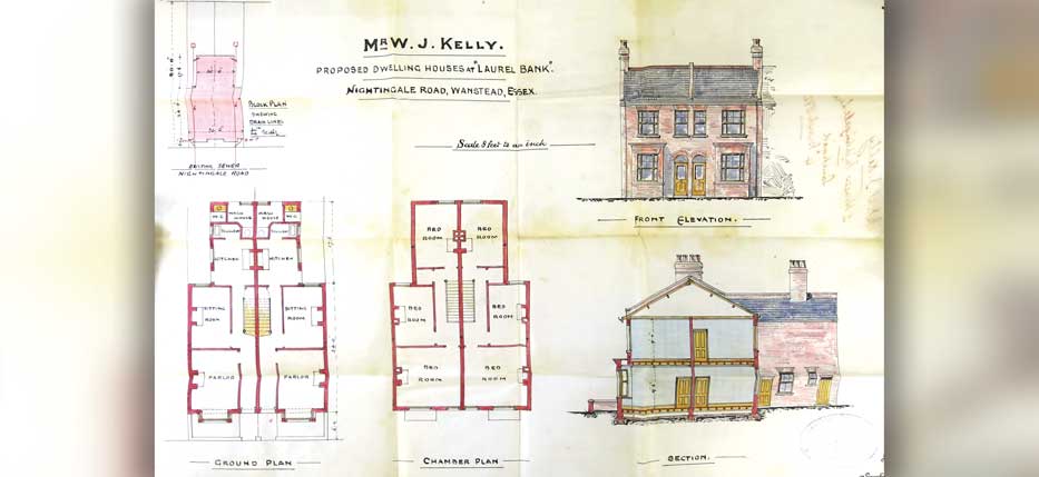
The Heritage Section of Redbridge Central Library holds over 40,000 building plans for Ilford and 14,000 for Wanstead and Woodford. These range from an entire area, drainage and street plans, churches and cinemas, stables and garages, down to alterations to houses including installing WCs and additional bedrooms. The majority of the plans are folded and stored in individual envelopes and numbered for identification purposes.
However, it should be noted that not all plans are available – sometimes, the original list records that the plan is missing and what has been left may be a document relating to the building. Where the original list records the exact location of the building, this still has some use to researchers, but where we are left with simply ‘one house’ in a particular street, the value of the record diminishes greatly.
Ilford Historical Society member Carol Franklin took on the task of computerising the details of every Ilford plan onto Excel spreadsheets. The details include the following: plan number, month and year, building type, house numbers, company, street name, area of Ilford, number of houses, proposer, builder and architect. So, for example, if you wanted to look at every plan held by a particular builder – Cameron Corbett, for instance – this can be done very quickly by filtering the information held on the spreadsheet.
A volunteer subsequently made a start on the plans for Wanstead and Woodford and catalogued 1,500 plans dating from 1959 to 1963. Sue Page, Development Librarian, gave me the more exciting task of going right back to the beginning of the archive for Wanstead, dating from 1858. So far, I have catalogued up to 1924, and I’m aiming to finish Wanstead up to the point it joined Woodford in the new Borough Council in 1934 by January 2020. Part of my work is to reassign houses to their modern street number as so many were given individual names or terrace numbers when they were built.
As a researcher into the streets and houses of the borough, the original plans and the lists are invaluable for my work into the growth of the area. This is especially true for the years before the earliest detailed Kelly’s Directory of 1900, where knowledge of when roads were laid out or the first houses built can be sketchy, to say the least. I am also constructing a full list of roads for the area with the date of them being laid out.
Some of my findings will be the subject of a talk at Wanstead Library this month, entitled Building Wanstead, where I will show the development of Wanstead over the last 150 years or so through a number of these plans.